 “Pope Francis on Monday slammed climate change doubters as “stupid” in the wake of a spate of hurricanes that have thrashed the US, Mexico and the Caribbean. “Those who deny it (climate change) should go to the scientists and ask them. They are very clear, very precise,” the pontiff said Monday during a press conference on the return leg of a five-day Colombia trip.” –Source
What this Jesuit Pope doesn’t seem to understand is that most people are not stupid when it comes to what he calls climate change because we are all on the same planet experiencing the weather changes. Yes, we had a few hurricanes, just as we do every year. And just so you know, those hurricanes were bad, yes. But they were not as bad as the media reported them to be. They are obviously pumping up the numbers to help the Pope in his long prophesied agenda regarding climate change. Check out this animation that compares hurricanes the last few decades. Irma, Harvey and Jose were large storms yes. But not THE largest. In fact, Matthew was much larger than Harvey, Jose and Irma, and Irma was only 15 miles wider than Katrina. And just so you know, Irma was 400 miles wide. But Sandy was 1120 miles wide literally engulfing Harvey, Irma AND Jose! In fact, you could fit another hurricane Harvey inside Sandy with 3 miles left over! But, Irma and Harvey got much more air time in the media than any other hurricane in history because we now have a Jesuit Pope who needs to do what Satan demands seeing how he knows his time is so short. Continue reading →


 As many of you know, there is a hurricane (Lane) bearing down on Hawaii.
 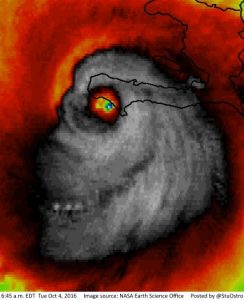 “Hurricane Matthew is a monster storm. Now it has a monster image to match. A sinister image of Hurricane Matthew, resembling a human skull, has lit up the Internet. The creepy satellite photo was posted Tuesday by Weather Channel senior meteorologist Stu Ostro as the hurricane made landfall in Haiti. The image shows the hurricane through an infrared camera lens. It’s been tweaked to show the storm in apocalyptic colors that accentuate the hurricane’s eye and make its teeth look like the comic book character Ghost Rider or the Grinch, some Twitter users suggested. It’s creepy, but in a nutshell, CNN meteorologist Judson Jones explains that “basically, scientists use color tables to identify the strongest part of the storm.” –
 Indonesian authorities raced on Monday to rescue victims of landslides and flash floods caused by torrential rain at the weekend that killed nearly 50 people and left many missing in the main island of Java.
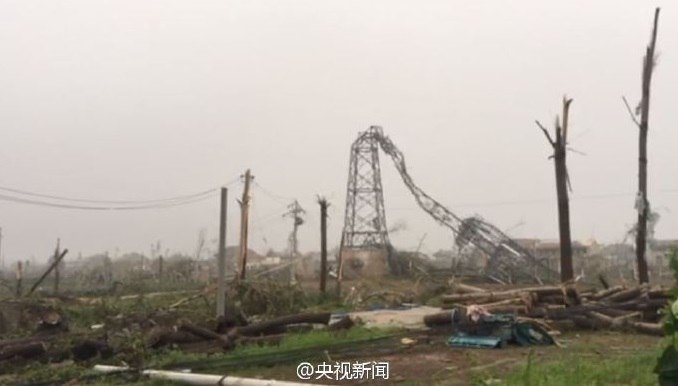 A cataclysmic tornado in Jiangsu province has destroyed buildings, left roads blocked and killed at least 78 people near Yancheng, China.
 The National Weather Service says a tornado that damaged or destroyed about 20 homes near the northeast Kansas town of Chapman was an EF4 with estimated peak winds of 180 mph.